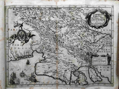
MAP OF CARNIOLA AND ISTRIA
This impressive map was made by a Carniolan nobleman of Italian descent and a Slovenian polyhistor, geographer and owner of a print shop in the castle of Bogenšperk (Wagensperg) near Litia as part of his efforts to design a geographical, historical and ethnographic work offering a complete picture of Carniola in a wider context. His military career and involvement in the war against the Ottomans put his academic career somewhat aside, but his collaboration with the European nobility, scholars such as Pavao Ritter Vitezović, or membership in the Royal Society of London made it possible to create important works such as The Glory of the Duchy of Carniola (Die Ehre des Herzogthums Crain, 1689) or the huge collection of graphic and book material. In the case of this map, it is a variant of the Mercator’s map of slightly larger dimensions from 1589 or 1640, depending on the version, which shows exactly the same area in a very similar manner, including very similar decorative elements of the sailing ships, cartouches and similar. Even within his printing workshop, the same map had several variants. This is evidenced by a similar specimen from the Felbar Collection (inv. no. 549), with a different content in the title cartouche also characterised by the Valvasor’s workshop. This map shows the area of Kranjska (Carniola in the Italian version) within the Holy Roman Empire, with the headquarters in Ljubljana (Laybach). The author also indicated the sovereignty over Carniola with a heraldic shield on the left edge of the map. Other decorations in the Adriatic area are sailing warships and a compass rose. Istria (Histria) is also shown on the map as a peninsula, with a specially designated Austrian part, the Pazin Shire (Mitterburg). The border to the Venetian possession is indicated by a dashed line. The toponymy is also different, with German toponyms on the Austrian land and Italian geographical names in western Istria. The title cartouche is in the upper right corner and clearly indicates the name of the author and the location of his printery (… delineata et recens edita Per Ioem Weichardum Valuasor L.B. Wagenspergi in Carniolia). The depiction of the relief is somewhat simplified by the scheme of the molehill, but the author also noticeably distinguishes between the deep plasticity of Učka and Ćićarija. The hydrographic content is enhanced in comparison with the maps by Bertelli, Camocio or Coppo, while the neighbouring countries such as Friuli and Liburnia can be difficult to recognize even in outlines due to simplification. The map was consolidated and bound in a book kept under inventory number 398 in the Felbar Collection (Carniolia antiqua et nova. Antiqua Japydica, Hyperborea, Celtica, Pannonica, Norica, Istrica, Carnica, Romana, Vandalica, Gotthica, Langobardica, Slavica, Avarica, Francica. Nova Germanica, Slavica, Francica, Bavarica, Austriaca…) The book was published as a three-volume edition during 1680 and 1681 in Ljubljana, and the publication was supported by the Carniolan classes.
VALVASOR, JOHANN WEIKHARD
