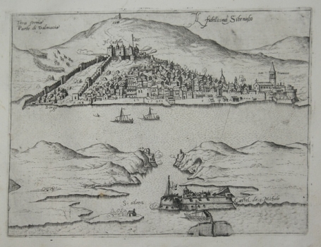
VIEW OF ŠIBENIK
This Šibenik veduta is almost identical, but still differs from the slightly more detailed Valegio’s map (no. 541). It also depicts a fortified Šibenik at the bottom of the bay, observed from a bird's eye view over the channel. The city is protected on the hill by the St. Nicholas’ Fortress at the entrance to the channel, bastions on both sides of the St Anthony’s Channel and two rows of mainland western ramparts that extend to St. Michael’s Fortress above the city. Unlike the Valegio map, this one shows a settlement that extends between the two ramparts. The city's architecture is faithfully depicted and therefore recognizable, such as the dome of the cathedral, the bishop's palace or the church of the Monastery of St. Francis. In addition to the military galleys in the channel outside the city gate, towards the mainland, recorded as the Tera ferma Parte di Dalmacia, infantry and cavalry troops are moving, indicating the Ottoman-Venetian conflicts in the hinterland, that is, the Ottoman incursions all the way to the city walls of Zadar or Šibenik. It is assumed that Valegio used Rota’s map of the same area as a template, or even that the Šibenik engraver Martin Rota Kolunić, as a local expert, connoisseur of geographic and cartographic basics and of the art of map-creation, and an associate of Zenoi's, engraved this map himself instead of Zenoi. This map is also very similar to Camocio's somewhat modified version of the same map from 1571, most probably also made collaboratively with Martin Rota (inv. no. 270). A version of this map was also published by Donato Bertelli in his work Civitatum aliquot insigniorum et locorum magis munitorum exacta delineatio, published in 1574 in Venice. In addition to Zenoi and Forlani, Šibenik-born Martin Rota and Natal Bonifacio also collaborated on this atlas.

