MAP OF SLAVONIA
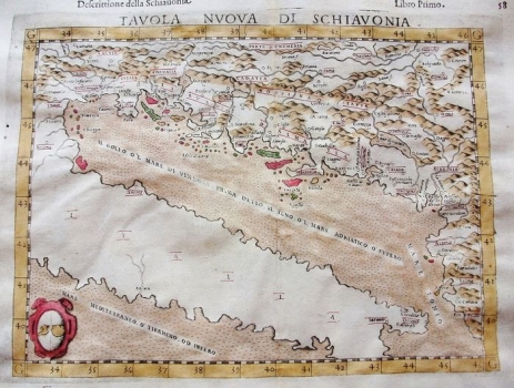
The map of Slavonia is part of the later supplemented Ptolemy’s plates (tabulae), more precisely part of a series of "new" or "modern" maps, which, in addition to the well-known original Ptolemy’s plates, also included new syntheses of the existing geographical and cartographic knowledge of the eastern Adriatic coast. Regarding the content and even the coat of arms in the bottom corner, the map is similar to Ruscelli's map of the same name from the Felbar Collection (inv. no. 36, but also maps 21, 87, 94 and 203), but it was created a little earlier and is smaller in size. It was published by the same publisher (Sessa) and therefore probably shares the same template. Given that the title of the original was La Geografia di Claudio Tolomeo Alessandrino, Tradotta di Greco nell'Idioma Volgare Italiano, da Girolamo Ruscelli, et hora nuovamente ampliata da Gioseffo Rosaccio, it was Rossacio who was responsible for enlarging this map following the same template. Of all these cartographers, Ruscelli dealt for many years with Ptolemy's Geography and its translations, and his “tavole” are considered to be the most high-quality modern adaptations of Ptolemy. He also relied on Gastaldi's knowledge of Ptolemy, and it was from him that he took over some of the plates in the mid-century. Ruscelli, like Rosaccio, collaborated with publishers from the Sessa family, and hence the combination of all these authors in the attribution of the map, although it was published after Ruscelli's death. It is again a representation of the area from the Gulf of Trieste to Albania and from the Adriatic coast to the Danube and the Drava in the north. From the Croatian countries, the author recorded the horonyms Istria, Libvrnia, Corvatia (in present-day northwestern Croatia), Croatia (on the territory of Slavonia), Bossina and Dalmatia. The Kvarner and South Dalmatian islands are especially vividly coloured. Given the same template, problems such as hard-to-read relief, coastline and hydrography were not corrected.
ROSACCIO, GIUSEPPE
