PEETERS, JACQUES: VIEW OF SISAK AND PETRINJA
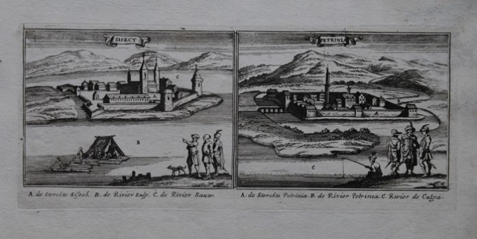
The sheet consists of two views. The view of the Sisak fort (Sisect) is on the left, while the medieval fort of Petrinja (Petrinia) is on the right. The emphasis is on fortification elements and appearance of buildings, while the natural environment in the vicinity is neglected. Text in the legend and symbols which explain the location of the strong fortress of Sisak on a narrow space between Sava and Kupa: A. de Sterckte Siseck B. de Rivier Kulp. C. de Rivier Sauw. is below the left view. The fortress is protected by strong ramparts, ravelins and waterbeds, and besides the ramparts and defensive corner towers, the towers dominate in the middle of the fort. People in oriental clothing looking at the fort from the opposite shore of Kupa are in the foreground. In this way, the Dutch cartographer emphasizes the closeness of the Ottoman enemy. Another detail is the representation of rafting and commercial exploitation of timber and its river transport along Kupa. This explains the natural-ecological and economic component of space. Petrinja, in a similar way protected by waterbeds, access bridges and ramparts, is on the right-hand side view. Unlike Sisak, some of the buildings within the walls look like Ottoman religious institutions or are marked by crescent moon symbols. This indicates that Petrinja was depicted at the time when it was under the Ottoman rule, before 1595. Watchers of the fortress dressed in Western garments are in the foreground, and beside them is pastorally depicted angler engaged in daily activity on the river was commonplace, as suggested by the cartographer. Legend of a map explaining the location of the fort between Kupa and Petrinjčica: A. de Sterckte Petrinia B. de Rivier Petrinia. C. de Rivier de Culpa. is below the view. The view was copper engraved by Gaspar Bouttats, known for high artistic value of cartographic material. This map is also a part of the Peeters series which depicts localities important to Dutch cartographers in the Habsburg-Ottoman wars between 1683 and 1699.
PEETERS, JACQUES
