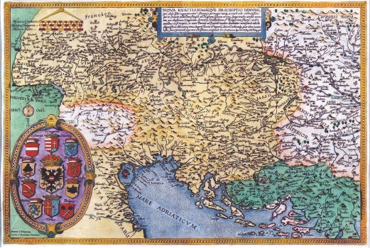
DE JODE, GERARD: MAP OF THE DANUBE BASIN
The map of the Danubian basin by Christian Sgrooten (approx. 1532-1608), a Dutch geographer and cartographer that was issued in the atlas edited by Cornelis de Jode. It consists of two sheets, and this is its part covering the west. In the representation of the Croatian lands some gross errors were made. The area to the west of Zagreb is named as "Windisch landt" (Slavonija), and the part to the south of the river Sava as "Croatia". Krbava ("Carbavatia") was wrongly placed in the coastal area between Senj and Split. The zone of the Dalmatian hinterland from Split to Dubrovnik he named "Sclauonisch landt", while to the northeast from Dubrovnik according to Sgrooten there was "Dalma" (Dalmatia). In additon to this, the names of the Roman provinces of Pannonia Inferior and Pannonia Superior are also indicated, what could lead to the conclusion that Sgrooten based his representation of the Croatian lands on the sources dating back to Antiquity. Coastal profiles are hardly recognizable. The island of Pag is represented in front of the town of Zadar, while a strip of land is connecting Pelješac and Korčula. In the lower left corner of the map there are coat of arms of Austria, Hungary, Erdelj, Bosnia, Wallachia, Bulgaria, Turkey, Bosnia, with House of Habsburg's coat of arms in the center. To the left of the cartouche are written the names of engravers: Ioannes a Deutecum, Lucas a Deutecum Fecerunt. A mileage scale is in the upper left corner in German (Milliaria Germanica), Hungarian (Milliaria Hungarica) and Italian miles (Milliaria Italica).

