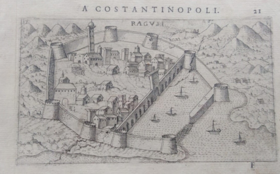
VIEW OF DUBROVNIK
In his veduta-equipped travelogue, and at the same time a guide to the eastern Adriatic from the end of the 16th century "Viaggio da Venetia a Constantinopoli per Mare, e per Terra…" Rosaccio included a presentation of one of the most important fortifications of the eastern Adriatic coast - the Venetian opponent Dubrovnik (Ragvsi). This is also the reason that the town is shown with very little detail. Rosaccio used information or templates from the local authors to show sites unknown to him. On this veduta, the town is firmly fortified on the land and sea side and panoramicly sketched before the earthquake, as evidenced by the high tower of the church of the Franciscan monastery and the town walls with nine towers. Within the walls there are two town districts, and a recognizable granary Rupe. The surroundings are schematic and without special details, with arbitrarily scattered molehills and elements of vegetation. It is one of the last prints from a copper plate, on which diagonal cracks from repeated use are already visible. The wind rose and the compass rose are also missing from the map. Above the upper edge of the map there is the name of the work (A Constantinopoli.) and page number 21. Below the lower edge of the map there is an engraved initial F. The content of this veduta, especially the view of the port and port fortifications, is very similar to the later 18th century Savonarola vedute of the Town. It was taken over from Valegi in the 17th century as a kind of overview of the geographical knowledge, and was created as a reaction to similar works by Forlani, Zenoi, Bertelli and Braun-Hogenberg. The mentioned similar map in the collection is registered under the inventory number 390.

