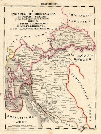
SCHLIEBEN, WILHELM ERNST AUGUST VON: HUNGARIAN COST, CIVIL AND MILITARY CROATIA
Inventory number 482
Original title: OESTERREICH Ungarische Erbstaaten. I. Königr. Ungarn, g. Von dem Ungarischen Littorale. Kreis 1. Fiume 2. Karlstadt. III Militaergrenze a. Die Karlstaedter Grenze
Publishing year: 1825
Place of publishing and publisher: Leipzig
Format: 26 x 19 cm
Technique: Lithograph, partialy coloured boundary lines
The author of the map is undisputedly van der Bruggen, because the map is identical to his signed map published in Vienna in 1737. The map depicts Slavonia, which covers the entire area between Sava, Drava and Danube, so it includes Varaždin and Zagreb in the west, extending to Belgrade to the east. Three cherubs hold a large map of Central and Northern Europe above the cartouche, as if they want to confirm the affiliation of Slavonia to Europe, and next to them there is a Slavonian coat of arms with three weasels. In the lower left corner, Virgin Mary blesses a book in which Srijem and Baranja are inscribed, and close to this, the mythological god of water is feeding one of the rivers that surround Slavonia.
SCHLIEBEN, WILHELM ERNST AUGUST VON
SCHLIEBEN, WILHELM ERNST AUGUST VON (1781-1839), a cartographer from Dresden, who worked as a chief district land surveyor in Leipzig. He was the first Director of the Statistical Association of Saxony, and made his career as a military officer and professor of military science. He carried out land surveys in Thüringen and collected data of the Kingdom of Saxony for statistical purposes. He published works in the field of land surveying, war history, mathematics and geography. As far as Croatian cartography is concerned, his most significant works were published in the Atlas von Europa from1829 and the Mittheilungen des statistischen Vereins für das Königreich Sachsen, which was published from 1831 to 1839.

