MAP OF THE PARISHES OF THE DIOCESES OF ZAGREB AND ZADAR UNDER THE AUSTRIAN RULE
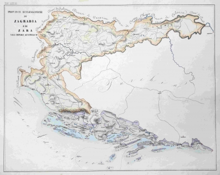
The map shows the parishes of the dioceses of Zagreb and Zadar under the Austrian rule. It was published in L'Orbe Cattolico ossia Atlante Geografico Storico Ecclesiastico Opera del Commendatore Girolamo Petri Officiale minutante della segreteria di Stato. In the area of the Zagreb diocese, apart from the center of Zagreb (Zagrabia), other episcopal centers have been recorded; Đakovo (Deakovar), Modruša (Modrussa) and Senj (Segna). The borders with the neighboring dioceses (from Trieste and Ljubljana in the west to Kaloč and Čanad in the east) are also marked. Across the border on the River Sava Turchia is marked, where only in the location of Sarajevo (Bosnia) the episcopal seat is marked, so there is no division into diocesan territorial units. In the Zadar diocese, in addition to the seat in Zadar (Zara), those in Šibenik (Sebenico), Split (Spalatro) on Hvar (Lesina) and in Dubrovnik (Ragusa) are marked too. In the Montenegrin hinterland, the only marked center is in Trebinje (Trebigne). In the maritime part of the eastern Adriatic (Mare Adriatico) archipelago the border division of the competencies between the dioceses is outlined. In addition to the thematic (confessional) content, the map also shows the basic roads, while the orography is highlighted by hatching. Above the upper left edge of the map there is the number of the atlas plate LXXIII.
PETRI, GIROLAMO
