MAP OF SERBIA AND THE BANAT
Inventory number 580
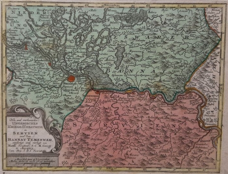
Original title: Neu und verbessertes Ungarisches Kriegs -Theatrum in Servien und dem Bannat Temeswar
Publishing year: 1740
Place of publishing and publisher: Augsburg
Format: 25 x 19 cm
Technique: Coloured copper engraving
The map of the Hungarian battlefield shows the demarcations of Banat (BANNAT) and Serbia (SERVIEN) on the Danube, as well as the borders of Slavonia and Serbia, which are separated not only by the border line but also by color. In addition, miniature schematic floor plans marked (anti-Ottoman) fortifications on the border river, such as Petrovaradin or Belgrade. Their significance is understandable in the light of the Belgrade Peace, because this is a German cartographer and graphic artist who was particularly interested in political relations. The confluence of the Sava and the Danube all the way to Belgrade is marked as Slavonia (SCLAVONIEN). The title of the map and the graphic scale are located in the lower left corner of the decorative cartridge. The step grid within the map is marked and entered.
SEUTTER, GEORG MATTHÄUS
GEORG MATTHÄUS SEUTTER (1678-1757), A German cartographer, geographer and map editor. He was Johann Baptist Homann's disciple, and later the greatest Homann successor's competitor. As graphic artist he started its work in Augsburg. Seutter engraved most of his maps by himself, while for their decoration other artists were entrusted, who in many cases left their signature next to the illustrations made. Seutter's workshop produced about 500 maps. Although these maps are very similar to those issued by Homann they have never reached its outstanding artistic level. The most famous Seutter's works are "Atlas Geographicus", 1725, "Atlas novus indicibus instructus" published in Vienna in 1730, "Grosser Atlas", 1734 and "Atlas monor praecipua orbis terrarum imperia" of 1744.