PANNONIA SUPERIOR / NORICUM / ISTRIA
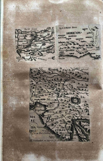
The Jesuit Slovenian priest, originally from Württemberg, served in Ljubljana as Dean of the Cathedral and Valvasor's teacher, and in 1679 he started a printery. In the mentioned conditions, in 1681 he printed one of the key works of the older Slovenian historiography, chronicling Carniola until the year 1000, under the full name Carniola Antiqua et Nova. Antiqua Japydica, Hyperborea, Celtica, Pannonica, Norica, Istica, Carnica, Romana, Vandalica, Gotthica, Langobardica, Slavica, Avarica, Francica. Nova Germanica, Slavica, Francica, Bavarica, Austriaca. As the famous local geographer and cartographer Weikhard von Valvasor worked on his other complete maps from the same edition, it is to be assumed that he also collaborated on the creation of these small formats. Like some other cartographers of the time, in quite different geopolitical conditions and border divisions, Slovene cartographers at the end of the 17th century also consciously remind of the glorious ancient history of the Roman provinces, which confirm the affiliation of the countries on the eastern Adriatic coast to the Western cultural circle. The authorship of these three maps has been attributed in the literature to Giuseppe Moletti, and Natale Bonifacio de Sebenico has also been mentioned as the alleged contributor, most likely as the engraver in the process of creation of the maps. The maps were created in the 1570s, and Schönleben then decided to reprint them and include them in his book due to above menetioned initiatives. In addition to the toponyms and horonyms of the ancient Roman provenance, the orographic and hydrographic content (molehills, schematized waters) was mapped in a tradition that partly reflected the Ptolemaic heritage, but also the influence of the Mediterranean maritime cartography, reminiscent of the way isolarios were made. The first of the three maps shows the area of Carniola and Upper Pannonia, from the Gulf of Venice in the west to the Danube in the north and Rab in the southeast. It is noted that this map, marked Fig. N.I. was attributed to Moletti, unlike the other Noricus map attributed to Nicolai Donnis as Fig. N.II. It depicts the area of Carniola from the Venice hinterland to the hinterland of Cres (Srepsa), Labin (Aluon) and Plomin (Fianona) on the western coast of Istria. The land part of the hilly interior marked by the oronym Cetius mons is very interesting.
SCHÖNLEBEN, JOHANN LUDWIG
