PEETERS, JACQUES: PLAN OF THE PETRINJA FORTRESS
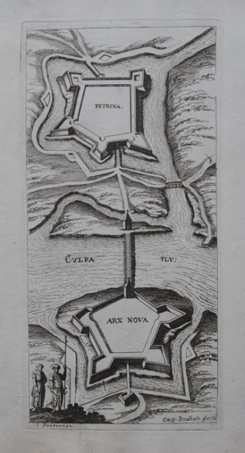
This panoramic plan of Petrinja is based on Hoefnagel's double map Petrina in ditione Turcarum - Petrina in ditione Christianorum, or a panoramic view and a ground plan that Georg Braun and Franz Hogenberg published in Civitates Orbis Terrarum as part of the same sheet in 1617. This map is a compilation, that is, a summary of the details from the double map , combining elements of both ground plan and panoramic view. The authors left decorative figures of the local population in the oriental dress in the foreground of the left map and drew them to what used to be the right part of the map or the plan of Petrinja, albeit with considerable reductions, especially in the toponymy. The restoration of Christian Petrinja after the war against the Ottomans ended only in 1617, and the plan testifies to the new pentagonal ramparts of the fortress. The surrounding watercourses and ditches are bridged with three new bridges. The new pentagonal fort Husarwar (Arx Nova) was built to accommodate cavalry . It is located on the island close to the western shore of the Kupa River. It was built in 1592 and is connected to Petrinja by the new bridge, while the old Turkish bridges are destroyed. Roads to the inland are drawn, although unlike the Hoefnagel map, they are not named, and neither is the dead-end branch towards the destroyed old bridge on Kupa. The author's attribution (Gasp. Bouttats fecit) is below the bottom edge of the plan. The map was made for the Dutch publisher Peeters, whose name is stated below the lower left corner of the map.
PEETERS, JACQUES
