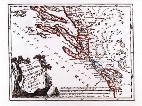
REILLY, FRANZ JOHANN JOSEPH VON: MAP OF SOUTHERN DALMATIA WITH THE REPUBLIC OF DUBROVNIK
The map shows the southern part of the Kingdom of Dalmatia and the Republic of Dubrovnik. The Venetian possessions that at that point comprised their biggest territorial space reached as far as to Bar in Albania. The delineation of boundaries between Dalmatia and the Ottoman Empire is indicated with accurate indication of the sea accesses at Klek and Sutorina that the Republic of Dubrovnik ceded to Turkey after the Treaty of Srijemski Karlovci of 1699. Namely, according to this peace treaty, the Republic of Dubrovnik firing direct boundaries with the Republic of Venice ceded a part of its territory at Klek and Sutrina to the Ottoman Empire. The oldest part of the Republic of Dubrovnik is colored blue, while the other parts are red (Mljet and the peninsula of Pelješac), the same as the territory of the Republic of Venise. The title is shown in the lower left corner of the map within a cartouche designed in the form of mantle cast over an olive-tree with grapevine growing next to it, symbols of Dalmatia. A mileage scale is expressed in Italian and German miles. This map was issued in Reilly's atlas "Schauplatz der Welt Atlas" 1789-1791.

