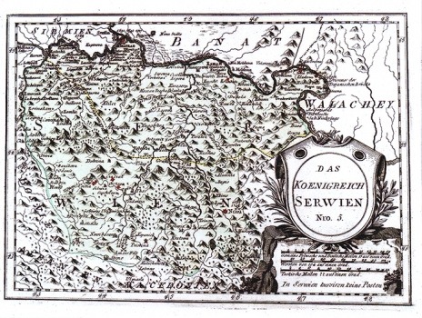
REILLY, FRANZ JOHANN JOSEPH VON: MAP OF THE KINGDOM OF SERBIA
The map shows the Kingdom of Serbia within its medieval borders and the change in their delineation occurred in the course of the 18th century during the Austrian-Turkish wars. By a dotted line is indicated the border established according to the Treaty of Požarevac by which Austrians obtained Turkish retreat south of Niš. During the Austrian-Turkish war engaged between 1737 and 1739 the Turks re-conquered the northern part of Serbia. By the peace treaty of Belgrade of 1739, a new frontier between the territories under Ottoman and those under Habsburg control was established i.e. put back along the Sava and Dunav rivers. On the territory of Serbia major fortresses are indicated. Next to Niš, a key fortress in defense of the southern Serbia, the annotation of the years 1737-1738 was written down in memory of the successful breakthrough of the Austrians up to the town of Niš and its short-lasted liberation. On the area of Kosovo there are annotations stating the years of the famous battles against Turks ( 1389, 1398, 1447). The title of the map is shown within a shield leant against a stone monument in the lower right corner of the map. A mileage scale is in Italian, Turkish and German miles. Below the scale there is a note stating that in Serbia there isn't post service organized. This map was published in Relly's atlas "Schauplatz der Welt Atlas" 1789-1791.

