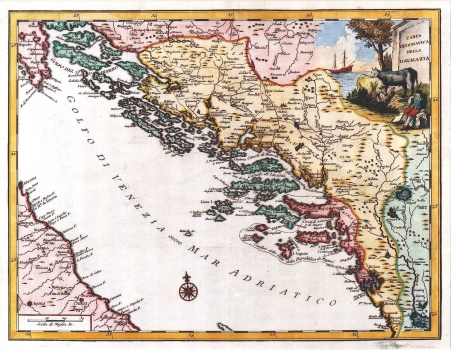
SALMON, GIOVANNI: MAP OF DALMATIA
Inventory number 140
Original title: Carta geografica della Dalmazia
Publishing year: 1753
Place of publishing and publisher: Venezia
Format: 33,5 x 43,5 cm
Technique: Copper engraving
This map was issued in Salmon's work "Lo stato presente di tutti i paesi e popoli del Mondo" published at Albrizzi in Venice in 1753. In this map of Dalmatia, is shown the Venetians owned part of the coast that reaches from the Istrian shores to the Bocche di Cattaro. The region of Dalmatia in which the author included the whole Herzegovina and a part of Bosnia is divided in administrative territorial units following the medieval parish boundaries and de delineation of the Venetian districts of that time. The delineation of the Dubrovnik Republic's boundaries is indicated with different marking. Judging by the coastal profiles and especially by the northern boundaries of Dalmatia, Santini drew this map on Cornelli's maps as sources. The title is shown in the upper right corner of the map incised in a stone monument with scenes of pastoral life at its sides. A mileage scale is in Italian miles.
SALMON, GIOVANNI
SALMON, GIOVANNI (IVAN, THOMAS) (1679-1767), an English historian and geographer who worked in Venice. He published maps of Istria and Dalmatia in the book Lo stato presente di tutti i paesi e popoli del Mondo, which was published by Albrizzi in Venice in 1734 and 1753, and by Ricciardo in Naples in 1738, 1744 and 1746. Among his published works are some maps of Istria and Dalmatia. In the mid 1730s he accompanied George Anso on his travels across the world. In the creation of his maps, he apparently used Venetian nautical maps of the areas in question. He published Modern History in 1725-1738, whereby he collaborated with Moll on the creation of the maps. In the mid-century, he published The Universal Traveler, or a Complete Description of the several Nations of the World in London.

