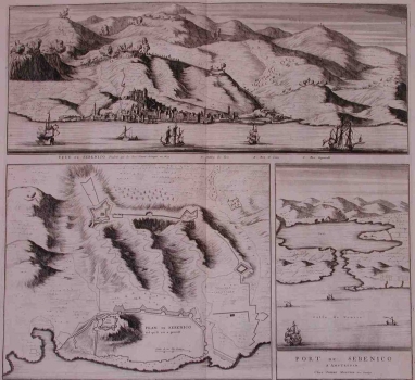
MORTIER, PIERRE: VIEW AND PLAN OF ŠIBENIK AND THE VIEW OF THE PORT OF ŠIBENIK
This three map images represent Šibenik from different perspectives. The view of Šibenik shows the topography of the town itself as the moment of an Turkish attack. Namely, the Turks attacked the town three times in 1538, 1647 and 1648. The greatest Turkish attack against Šibenik was launched in 1647 when a Bosnian pasha laid siege to it with 10 000 soldiers. It seems most likely that this view depicts that event. The second map image shows the plan of the town’s fortification system. At the highest point the fort of St. Anna can be seen. From that fort to the present-day port in the front of present-day park the wall of medium thickness reinforced by round and square towers was running. A less thick wall was running along the coast and inside the area enclosed dwelling houses of the citizens of Šibenik were built. That wall was provided with 7 city gates. Land gates were in the vicinity to present-day theatre. Below the church of St. Anna groundwork of already pulled down walls of a former castle can be seen, from which the wall runs up to the coastal ramparts. The second wall stretches from the fort of St. Anna towards the coast. From there was running the landward side wall that encircled the suburb of Dolac. Two forts stand above the town, that of St. Johann built around 1570 at the beginning of the Candian war and the fort Barone built at the former site of the structure constructed, in 1648, by that the commander of the Venetian troops Degenfeld for his temporary fortification. The third view shows the topography of the port of Šibenik. We can see two small forts defending the entrance into the port of Šibenik set one opposite the other at entrance to the channel. In 1546, on the outer part of the entrance a large bastion of St. Nicolas was built which also shown in the plan.

