CONNECTION OF THE ADRIATIC SEA WITH THE KUPA RIVER CATCHMENT
Inventory number 554
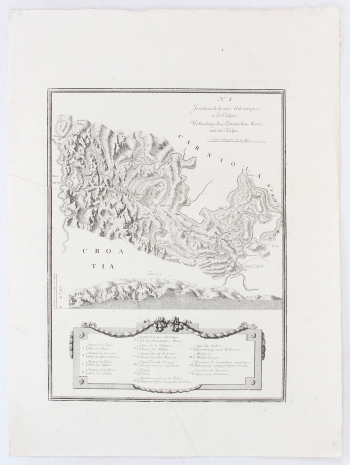
Original title: Jonction de la Mer Adriatique à la Culpa / Verbindung des Adriatischen Meeres mit der Kulpa
Publishing year: 1785
Place of publishing and publisher: Wien
Format: 38,5 x 50 cm
Technique: Copper engraving
This thematic map of the traffic connections of the Kupa River tributaries to the closest point of the Adriatic Sea is important when analyzing devising and planning of the economic development of this area. The organization of the most cost-effective way of transporting goods was based on the search for the shortest route for water transport, either by river or by sea. Therefore, the titles in French and German in the upper corner of this map, marked No 1., imply the importance of the Adriatic connection with the Kupa (Jonction de la Mer Adriatique à la Culpa / Verbindung des Adriatischen Meeres mit der Kulpa). Below these titles is a graphical scale measured in German miles. The shortest connection established by hydroengineering is on the route from the Kupa (and the Dobra) near Brod, through some intermediate watercourses and reservoirs, to the mountainous road, which goes in a few arms from Karlovac via Ravna Gora to Bakar (Buchari) and towards the Rječina River. The Carolina Road was opened for traffic in 1727. In the lower left corner of the richly illustrated cartouche is a map key, and above it is a section of the elevation profile in the area. The importance of such traffic routes is certainly defined by the military-territorial organization of the Military Frontier area in the immediate vicinity, especially in the Ogulin area.
MAIRE, FRANCOIS JOSEPH
FRANCOIS JOSEPH MAIRE (1738-1801), a French mathematician, hydrographic engineer and cartographer, a monk who taught mathematics at Collège Mazarin, the forerunner of the University of Paris. His most often hydrographically motivated cartographic representations were usually focused on geographic-engineering measurements and channels and passageways, such as the waterway Dardanell, Bosporus, river channels on the Kupa River and tributaries, and similar, or their engineering and construction dynamics in space. J.E. Mansfeld was the engraver wwho worked on some of his maps. After Müller’s map of the Croatian regions was published in 1770, Austria initiated activities of surveying the whole territory of the state. Several stages of surveying were carried out on the territory of the Croatian countries, and the cartographic engineers were particularly interested in the military operations on the borders with the Ottomans that also left their mark on the planning of the land and water routs. Since the 1780s, there was an intense debate about the construction of canals that would connect the centers of the Monarchy with the ports in the Adriatic, in which Maire, the engineer, played an important role. In 1786, he proposed the construction of a canal system that would radially spread from the Viennese capital to the outermost ports and would connect a larger number of sites into a single navigation network. The canals were conceived as an 18th-century railway, one branch connecting Vienna, and Trieste and the other Vienna and Kraljevica. Out of many even feasible plans, most were not realized, except for the one to Wiener Neustadt. As an alternative to the Carolina Road, which since 1726 served for the transportation of intermodal freight from ships in Karlovac to the Adriatic ports, in 1796 Maire proposed for the same purpose the regulation of the Kupa River and connecting Karlovac with the sea by canals . However, as the planned costs, but also the realization possibilities were questionable, his project was never approved.