MAGINI, GIOVANNI ANTONIO: MAP OF ISTRIA
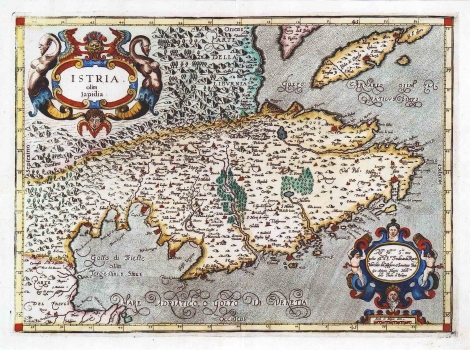
This map of Istria was issued in Magini's Atlas of Italy. The Atlas was published after Magini's death. His son Fabio, done the preparation work for its printing in Bologna in 1620 at Sebastian Bonomi printing house. The map represents the Istrian peninsula with parts of the Gulf of Kvarner. Although he undoubtedly worked on Kopić' map of Istria as his source, Magini corrected many of Kopić's errors. The town of Rijeka, wrongly located by Kopić on the northeastern coast of Istria, Magini located correctly in the bottom of the Gulf of Kvarner that he named "Vumkovinx". The topography is shown with shaded molehills spread all over the peninsula. The mountainous character of Ćićarija is accentuated, as well as the Mount Učka area (M. Maggior). Forests are shown with tree symbols in the Dragonja and Mirna zones and around Lim channel. Magini's map of Istria, is the best cartographic representation of this area made during the 17th century, so, is no wonder that it was subsequently reproduced by many cartographers, especially the Dutch ones. The title is shown in the upper left corner of the map in a cartouche decorated with masquerons and monsters. In the lower right corner is a cartouche with dedication text. The author wrote: "All Illmo Sor mio prone ossmo il Sor Fernando Riaria Marchese di Castiglione Senatore Bol Gio Antonio Magini Mathco dello studio di Bologna".
MAGINI, GIOVANNI ANTONIO
