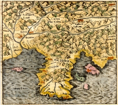
MÜNSTER, SEBASTIAN: MAP OF ISTRIA
The first edition of this map of Istria by Münster was included in the original edition of his most noted work “Cosmographia Universale” dating from 1550. This example is a later issue dated 1580, almost 30 years after his death. Although Münster made his map of Istria after the noted map of Istria by Petar Kopić, which generally served as a source for all the maps of the Istrian area produced during the 16th century, it is difficult to recognize the mastery in representing this peninsula demonstrated by Kopić. The relief is shown schematically and socio-geographic inventory of the map is very scarce. The extent of forests indicated with the symbol for tree characteristic of Münster’s maps. The town of Rijeka (S.Veit) is mistakenly placed on the Istrian peninsula.

