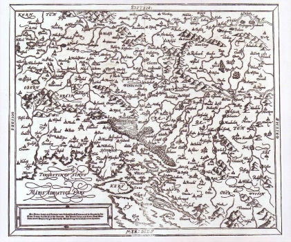
MÜNSTER, SEBASTIAN: MAP OF SLAVONIJA, SLOVENIAN MARK, BOSNIA, CROATIA...
Inventory number 122
Author: MÜNSTER, SEBASTIAN
Original title: Sclauonia oder Windisch Marck, Bossen, Crabaten etc.
Publishing year: 1588
Place of publishing and publisher: Basel
Format: 30 x 35,6 cm
Technique: Copper engraving
This map was issued in 1588 edition of Munster's Cosmografia. It is a re-make of Münster's map "Descriptio totius Illyridis" complemented with data from Hirschvogel's map of Slavonia and Croatia. Beside Carniolan and Slovenian marks the map shows the historical outline of Croatia up to the river Vrbas, and the western part of the medieval territory of Slavonia. The topography is shown only sporadically, while forested areas are represented with a tree. In the lower left corner the text in a simple chase describes the rivers: "Die Drava kompt auss Kernten vo Villach durch Stewrmarck in Ungarn zu der Statt Trazat da fellt sie in die Thornaw.
MÜNSTER, SEBASTIAN
MÜNSTER, SEBASTIAN (1489-1552), a German geographer and cartographer. He was a professor of cosmography in Bern. His most well-known work, Cosmographia, was published in 1544 and it had 24 editions. He was the editor of several editions of Ptolemy's Geographia (1540, 1541, 1542, 1545, 1551, and 1552).

