MORTIER, PIERRE: VIEW OF VRANA
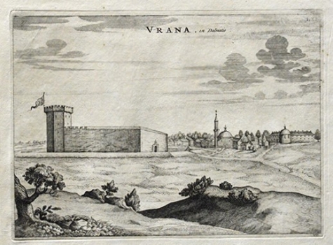
The old Croatian town and once seat of the homonymous feudal domain is situated near the Lake of Vrana in Dalmatia. This Mortier’s view shows the fortress and the settlement of Vrana as they looked like in 1527 after having been captured by Turks and governed by the Turkish lords of the Atlagić and Durakbegović families. In the foreground, the fortress of Vrana is featured as quadrangular fortification with a tall six-sided tower displaying the Turkish flag. In the background, we can see the settlement of Vrana, with one of the mosques of the time (during the period of Turkish rule in Vrana were built three mosques). Vincenzo Maria Coronelli issued an identical view in his atlas “Isolario dell Atlante Veneto”, so that this Mortier’s view is just republished Coronelli’s earlier map. At the time of publishing of the edition of Mortier’s atlas in which this view was inserted, Vrana was no longer under Turkish rule. In fact, after 1684 when the Turks were pushed out of Vrana, the Venetians regained this fortress.
MORTIER, PIERRE
