MERCATOR (KREMER), GERHARD: MAP OF FRIULI, CARNIOLA, ISTRIA AND WINDISH MARK
Inventory number 189
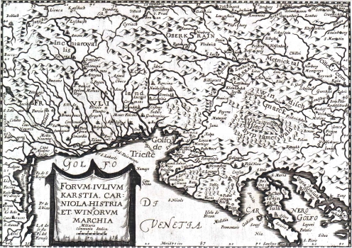
Original title: Forum Julii, Karstia, Carniola, Histria et Windorum Marchia
Publishing year: 1635
Place of publishing and publisher: London, Sparke & Cartwright
Format: 16,5 x 23 cm
Technique: Copper engraving
This Mercator's map of Friuli, Carniola, Istria and Windish Mark was included in the English edition of the atlas by Jodocus Hondius published after the original Hondius' cooper plates of his Atlasa Minor were sold in London. Michael Spark and Samuel Cartwright published the London edition of that atlas in 1632. This map differs from the original by Mercator only in the way its cartouche is artistically designed. While the cartouche featured on the original is finely engraved in elaborated mannerist style, the cartouche of this map is much simpler drawn in the form of drape containing the map's title and the scale. The outline of Istria is deformed and only a few place names are given. Amongst the hydrographical phenomena, the lake of Cerkniško jezero (Czircnizer See) is the dominant feature. It is obvious that the author was much more acquainted with the Friulian rivers then with those flowing through the Istrian region, while the islands Sveti Nikola (St. Nicolas islands) and Brijuni are identified only by their names. Especially interesting is the way in which the island Cres is presented on this map as being made up of three islands: (Cherso), Beli (Cao) and Porozina (Perosino). The scales are in Italian miles (Miliaria Communia Italica).
MERCATOR (KREMER), GERHARD
One of the most prominent Dutch cartographers, beside Ortelius, is surely GERHARD KREMER, best known as GERHARD MERCATOR (1512-1594). In distinction from its Dutch contemporaries he produced his atlases and maps by himself. Generally, he fought methods of drawing maps upon sources consisting of somebody else's map images or written documents, while he wanted to make a map applying mathematical and geodetic principles. In 1569 he published his world map made using the projection that took his name (the projection of Mercator) - a novelty which was, in fact, the biggest Mercator's contribution to the world's cartography. His heirs published the complete version of his atlas, in 1595, entitled "Atlas sive Cosmographicae". Prior to this atlas, a number of smaller sets of maps were issued during Mercator's lifetime. Especially valuable are his maps of the New World showing new discoveries. As Mercartor gave his entire attention to the Western Europe and the New World, for drawing of the Croatian lands he was mostly using numerous older sources, which is to be seen from the inscription of medieval state and county boudaries. His maps of "Slavonia, Croatia, Bosnia cum Dalmatiae parte" and Karstia, Carniola, Histria et Windorum Marchia" show the image of the Croatian lands before the Turkish invasion. His atlas went through some forty editions.