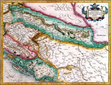
HONDIUS, JODOCUS: MAP OF SLAVONIA, CROATIA, BOSNIA AND PARTS OF DALMATIA
Henricus Hondius published this issue of Mercator’s map of Slavonia, Croatia, Bosnia and parts of Dalmatia in the Mercator-Hondius atlas “Atlas Maior”, after Mercator’s death. In 1604, he bought the copperplates of Mercator's atlas and, in 1606, published a new enlarged edition of Mercator’s atlas to which he added another 36 maps.
As typical for the maps of Dutch output, this one shows the Croatian lands within not quite accurate medieval boundaries. The border between Croatia and Bosnia is delineated somewhat easterly from the river Una, Dalmatian borders are pushed deeply inland embracing the whole of Herzegovina. Zagreb is indicated twice, once as Agram and then as Zagreb. The map is embellished by the coats of arms of the Republic of Venice, the House of Habsburg and the Ottoman Empire. The title of the map is in the upper right corner in an oval cartouche. A mileage scale is in German miles. The text in Latin on the backside gives the information on some of the lands shown together with the coordinates of some settlements. Written pages bear the numbers 299 and 300.

