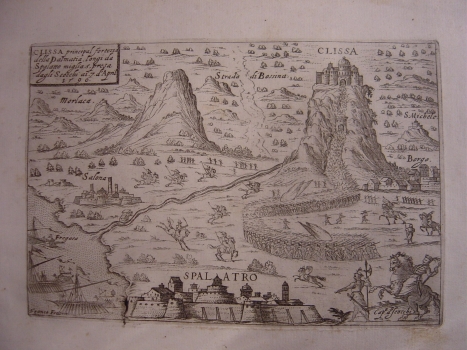
FRANCO, GIACOMO: VIEW OF KLIS
It is most probable that this view of Klis comes from the Venetian isolario titled «Descrittione geografica delle isole, citté, & fortezze prencipali, che si trouano in mare nel viaggio da Venetia a Costantinopoli» printed by Franco in Venice in 1597. Franco’s isolario was made upon one similar Camocio’s work on which he based to a great extent majority of views relating to the towns on the Croatian side of the Adriatic Sea. This view features Klis and its suburb as it was on 7th April 1596. In the foreground we see Split next to the ruins of the antique Salona and warships at anchor. In the interior, Klis with surroundings is featured as a scene of a great battle fought between local inhabitants and Turks who at that time had Klis in their possession. Namely, the Turks conquered Klis in 1537, but local militia (uskoks) took control of the fortress in 1596 though only for a brief period. Sandžak-beg Mustafa responded to that by sending over ten thousand soldiers under the walls of Klis. General Juraj Lenković (we can see him in the lower right corner of the view) tried to help save Klis and its defenders who were few in number (some 1500 men), with some thousand soldiers and uskoks, but he was wounded and forced to retreat. The Turks conquered Klis as soon as May the 31st. However, this temporary liberation echoed across the whole of Europe, as well as among local inhabitants and uskoks and gave strong support to their future efforts. Klis stayed in Turkish hands until 1648 when it was finally liberated.

