FORTIS, ALBERTO: MAP OF ZADAR AND ŠIBENIK AND THE SURROUNDING AREAS
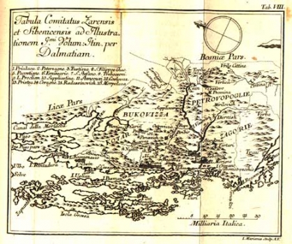
This map was issued in the book of travels “Viaggio in Damazia” by Frotis first published in 1774 in Venice. The book of travels is made up of two parts bound together. One map is featured preceding each part. The first edition has on its frontispiece the map of Zadar and Šibenik and their countryside and the second part begins with the map showing the towns Trogir, Split and Makarska with their surrounding areas, the Adriatic coast, the river Neretva and some islands. This map comes from the German edition published in Bern in 1776. In this edition only the second part has the map featured on its frontispiece. On the map of the Zadar and Šibenik surrounding area the outlines are marked of the territorial units – districts (Contadi) of Zadar and Šibenik that comprised the area stretching from the southern parts of the mountain chain of Velebit in the west to the localities of Drniš and Rogoznica in the east with the appertaining islands which are: Dugi otok, Pašman, Ugljan, Murter, the Kornati islands and the archipelago of Šibenik. In congruity with scientific research conducted by Fortis, besides on the representation of settlements the representation of the hydrographical and other geographical features is the object of focus on this map. Although the topography is shown pictorially with shaded molehills their distribution and density correspond to the exact topographical proportions of the relief of the northern part of Dalmatia. Identified by their names are only Monte Trtari (Trtar) and Monte Promina (Promina). Amongst the identifiable hydrographical phenomena the flows of the rivers Zrmanja, Krka with Butišnica, Čikola and Cetina with its source (Vrillo Cetine) are indicated. After the maps of Bože Bonifačić of Šibenik and Martin Rota Kolunić of that particular land area this map is considered as showing a good degree of accuracy. The engraver who designed the map on the cooper plate was L. Marianus.
FORTIS, ALBERTO
