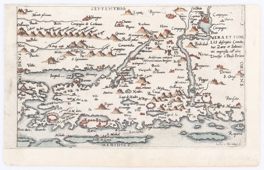
AP OF THE ENVIRONMENT OF ZADAR AND ŠIBENIK
This regional map shows part of the central Dalmatian land and islands, with the hinterland of Zadar and Šibenik. Forlani was familiar with the Venetian maps of the Zadar-Šibenik environment, such as Pagano's or Rota's works. His map shows Zadar and its coast, from the island of Pag (Pago) in the west (Occidens) to Drniš (Dernisi) in the east (Oriens). The northern boundary of the depicted area is the coastal side of the Dinaric ridge, to the line marking Plješevica (Monte plisiua). The larger fortified cities (Zadar (Zara), Nin (Nona), Šibenik and Knin (Tina) are depicted as coloured panoramic plans, even of recognizable architectural, most often fortified forms, which is unusual for a map of such a small scale. The military-strategic informative nature of this map, created in the midst of the Ottoman-Venetian wars, is evidenced by fairly detailed accounts of smaller fortifications in the hinterland. The author omitted the border divisions or data referencing the territorial division between the warring sides. The relief is stylized and shown with shaded molehills, and the hydrography, especially the Krka and Zrmanja flows, is overstated. The bottom corner shows the signature of the author J. Deutecum (Ioannes a Dotinchum f.). The map is very similar to Forlani's eponymous and earlier version of larger format from 1570 (La vera et fidelle discritione....), but also to the half-a-century younger Merian map of the same area (Tafel der Stätte…, inv. no. 67). This version was published in the Speculum Orbis Terrae atlas by Cornelis De Jode. Both maps were created using map templates of the Zadar-Šibenik hinterland by Martin Rota Kolunić from 1570, and Natale Bonifacio from 1575. With the latter, this map shares a note on the ruins (Bergane) west of Knin.
DE JODE, GERARD
