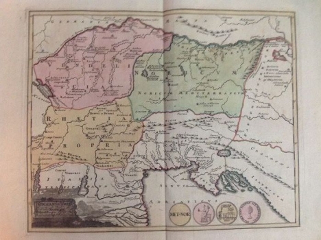
THE ANCIENT PROVINCES OF VINDELICIA, RHETIA AND NORICUM
The map highlights the ancient provinces (Vindelicia, Rhetia and Noricum) in the area of today's Austria, Slovenia, Bavaria and Switzerland, as well as the unpainted area of northern Italy all the way to the northern Adriatic. It is here that the hydrographic network of the Adriatic basin is extremely pronounced. The ancient provinces and the borders between them are especially emphasized by different colors. The title of the map and the authorization are located in the lower left corner in a simple architectural cartouche, and along the lower edge are four medallions with antique motifs. In the area of the Croatian lands, the people living there have been recorded, from Kolapljani (Kolapini) in Pokuplje to Flanates near Rijeka. Other territorial units Istria, Illyricum and Pannonia Superior were recorded, as well as the most important rivers (Savus and Dravus fl.). The specificity of the map is the recorded island on the River Sava near Sisak (Segestica insula), which is often repeated by Western European sources on ancient historical maps.
WEIGEL, JOHANN CHRISTOPH
