VALLARDI, PIETRO AND GIUSEPPE: MAP EXHIBITING THE ROUTE BETWEEN RIJEKA AND KOTOR
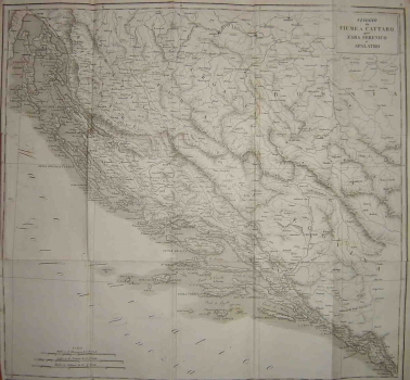
The map shows the area extending from Rijeka to Kotor described in the travel book «Itinerario italiano, o descrizione dei viaggi per le strade più frequentate alle principali città d’Italia». The above mentioned travel book published in Milan by brothers Vallardi, Pietro and Giuseppe was issued in several editions. Some of the best-known editions appeared in 1818, 1820, 1822, 1826,1828 and 1836. The map shows Dalmatia, Croatia (including the Military Border area), a part of Slavonia, Boka Kotorska and the islands of the Kvarner bay archipelago, as well as much of Bosnia and Herzegovina. This map was enclosed to the travel book to help the reader better understand the route described in the book. The map features the boundaries between the lands shown, as well as major settlements, the network of rivers and basic topographical features. Particularly interesting is the place name appearing on the portion of the map that shows the present-day western Bosnia identifying the area between the Una and Vrbas rivers as Turkish Croatia. This was to illustrate that before the Turkish invasion that part of Bosnia appertained to the Croatian Kingdom. The memory of its former belonging to Croatia was kept alive in the name of Turkish Croatia reappearing on a certain number of maps over a period of time comprised between the 16th and the 19th century. Besides the said map, the travel book also contains two very detailed maps, one showing the area between Zadar and Kotor (see No. 278) and the other depicting the territory of Istria (see No. 279).
VALLARDI, PIETRO I GIUSEPPE
