VALLE, GIOVANNI: KARTE VOM VENEZIANISCHEN DALMATIEN
Inventory number 138
Author: VALLE, GIOVANNI
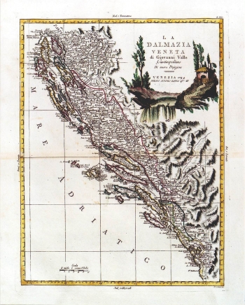
Original title: La Dalmazia Veneta di Giovanni Valle Giustinopolitano Di nuova Projezione
Publishing year: 1794
Place of publishing and publisher: Venezia
Format: 40 x 30,5 cm
Technique: Coloured copper engraving
This map of Dalmatia was published in the atlas of Antonio Zatta. It shows Venetian possessions in Dalmatia within the borders established by the Treaty of Požarevac concluded in 1718 between the Venetian Republic and the Ottoman Empire. By this treaty were established the northern borders of Dalmatia stayed almost the same as nowadays. The borders of the Republic of Dubrovnik are also shown as well as Turkish cordons at Klek and Sutorina. The title is in the upper right corner of the map. A mileage scale is expressed in common Italian miles (Miglia communi d'Italia).
VALLE, GIOVANNI
GIOVANNI VALLE, a Venetian editor and cartographer. He worked during the second half of the 18th century. His cartographic works were published at ANTONIO ZATTA's (approx. 1757-1797), printing-house in Venice. In the period between 1775 and 1785 he published "Atlante nuovissimo" in 5 volumes, and in 1799 "Nuovo Atlante".
