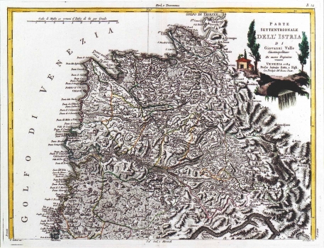
VALLE, GIOVANNI: MAP OF THE NORTHERN ISTRIA
Inventory number 136
Author: VALLE, GIOVANNI
Original title: Carte settentrionale dell Istria di Giovanni Valle Giustinopolitano Di nuova Projezione Venezia 1784
Publishing year: 1784
Place of publishing and publisher: Venezia
Format: 31 x 40,5 cm
Technique: Coloured copper engraving
This map was with all probability issued in the atlas of Antonio Zatta published in Venice in 1784. The map shows the southern part of Istria up to the Lim channel and the town of Pazin. The southwestern border of the county of Pazin is also outlined, and the Venetian possessions in Istria are shown divided by district. The title is in the lower right corner inscribed in a stone tablet and the illustration in color showing ships on the sea and the stretch of a coast complete the decoration. In the lower left corner the engraver put his signature: "G. Zuliani inc", and in the right one "D. Colussi scr". A mileage key is in common Italian miles (Miglia communi d'Italia).
VALLE, GIOVANNI
GIOVANNI VALLE, a Venetian editor and cartographer. He worked during the second half of the 18th century. His cartographic works were published at ANTONIO ZATTA's (approx. 1757-1797), printing-house in Venice. In the period between 1775 and 1785 he published "Atlante nuovissimo" in 5 volumes, and in 1799 "Nuovo Atlante".
