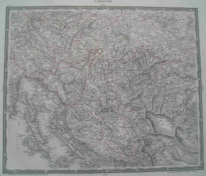
WOERL, JOHANN EDMUND: EASY-TO-READ TOPOGRAPHIC MAP OF CENTRAL CROATIA
This detailed topographic map at a scale of 1:500 000 was issued as part of the Atlas of Central Europe (Atlas von Central Europa) published by Woerl in 1838. The sheet identified as «Carlstadt» shows the eastern coast of Istria, Hungarian littoral (Rijeka with surroundings), most of Croatia with the Military Frontier from Senj in the south to Ivanić in the north, as well as the western part of Bosnia identified as Turkish Croatia. The relief is represented in a very plastic way by hachuring (short lines used on maps to shade or to indicate slopes and their degree and direction). The road network is marked in red, so, among others, we can see the Caroline, Josephine and Louisiana roads that connected Karlovac with Rijeka, Bakar i.e. Senj. The map’s title appears along the upper margin edge. Besides in meters, the map’s scale is expressed in Austrian postal miles and in German miles.
WOERL, JOHANN EDMUND
