WEIGEL, JOHANN CHRISTOPH: MAP OF NEW FRONTIERS AS ESTABLISHED BY THE PEACE TREATY OF KARLOVCI OF 1699
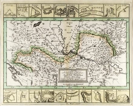
The map shows new boundaries between the Ottoman Empire and the Habsburg Monarchy as established by the Treaty of Srijemski Karlovci concluded in 1699 following the end of one of many Austrian-Turkish wars. By the new border delimitation the regions of Slavonija, Lika, Krbava and the military borderland of Banksa krajina were returned to Croatia. Along the map’s edge the plans of fortress of major importance are featured: Gradiška, Slankamen, Morović, Osijek, Petrovaradin, Beograd, Brod, fortified gorges in Erdelj, the Rock of Filibe by the river Maroš, Jasenovac, Dubica, Kostajnica, Gvozdansko, Novi, Slunj, Bihać, Dežnik and Borićevac. This map was reduced from the Map of Ottoman-Habsburg border delimitation elaborated in detail, which comprises 24 folios produced by the end of 1699 by the military topographer Johann Christian Müller. The title is placed in the lower part of the map in a simple rectangle shaped box.
WEIGEL, JOHANN CHRISTOPH
