VALCK, GERARD: MAP OF DALMATIA, SLAVONIA; CROATIA, BOSNIA, SERBIA AND ISTRIA
Inventory number 84
Author: VALCK, GERARD
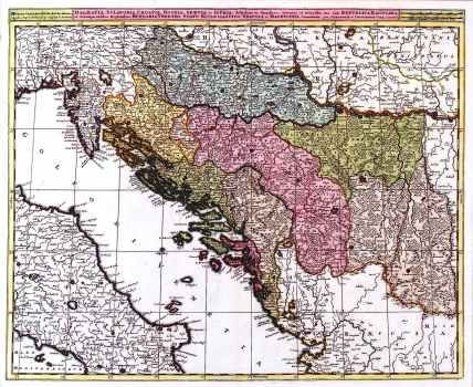
Original title: Dalmatia, Sclavonia, Croatia, Bosnia, Servia et Istria, distributa in singulares Ditiones et Dioceses, una cum Republica Ragusiana, et circumiacentibus Regionibus, Hungaria veteriis, statu ecclesiastico, Neapoli et Macedonia
Publishing year: 1695
Place of publishing and publisher: Amsterdam
Format: 49 x 59 cm
Technique: Coloured copper engraving
The map was published in the "Atlas Contractus" of the brothers Valck in 1695. It shows the whole region which is today Croatia. Croatia and Slavonia roughly cover their medieval outline. Dalmatia is shown following the Venetian example enlarged so that it comprises the whole territory of Herzegovina that at the time was in fact under Turkish control. A title cartouche and a mileage scale are placed above the upper margin edge of the map.
VALCK, GERARD
VALCK, GERARD (GERARDUS VALCK) (1652-1726) and LEONARD VALK (1675-1755), a son of Gerard, who continued the work of his father, and worked in London. The father and son worked together as cartographers, engravers, globe makers and publishers of artistic publications in Amsterdam. In collaboration with Schenk, they received several copperplates for engraving from Blaeu (1683) and Jansson (1694). They published their Atlas in 1702, Orbis Terrarum in 1680 and Large maps of the World and 4 Continents in 1680. Leonard Valk published the Republica Veneta independently in 1690.
