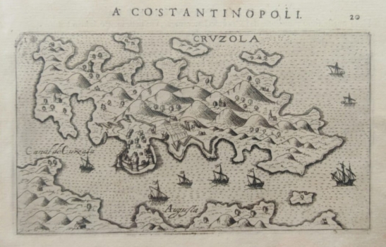
PANORAMIC MAP OF THE ISLAND OF KORCULA
The panoramic map shows the entire island of Korcula (Krvzola) with a particularly prominent and oversized peninsula where the largest town on the south side of the island (approximately at the site of today's Prizba), is fortified on the coastal side. The island is somewhat shortened in length. According to the appearance of the defensive towers in the port, the author probably placed the veduta of the town of Korčula, with recognizable shipyards in the side ports, on the wrong coast of the island, on the south instead of on the north side. As both the wind rose and the compass rose are missing from the map, it is to be assumed that the author turned the island in such a way that Pelješac is south of it, while in reality it is the other way around. Although foreign authors, including the Venetian author of this guide, used local information or cartographic templates of domestic authors, in this case a big mistake was made. In the closer mainland hinterland of that peninsula town, the settlements are visible as well as the cultivated fields to the east. Only a few scattered churches have been drawn on the correct site of ancient Korčula. The orography of the interior of the island is expressed by molehills. In the northern and southern waters of the island there is a rich display of islets and cliffs. In the waters of the main port (Canal de Curzola) a larger number of sailing ships can be seen, especially towards Lastovo. Above the upper edge of the map there is the name of the work (A Constantinopoli.) and page number 20.
ROSACCIO, GIUSEPPE
