MAP OF THE NORTHERN COUNTRIES OF THE AUSTRIAN EMPIRE
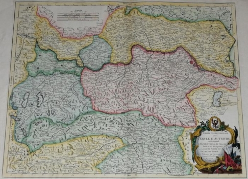
The map shows the northern Austrian countries in great detail and with a dense data grid, identical to the earlier Vaugondi's unpainted copperplate engraving with the inventory number 587. The cartographic content is identical and very rich. The Habsburg hereditary lands (Upper and Lower Austria, Styria, part of Carinthia) before the Napoleonic Wars are shown. The title of the map is in the lower right corner in a richly decorated Baroque cartouche, with heraldic insignia and military weapons and flags. Below the top edge are multiple graphic scales. This map was published in 1777 in the work Atlas Universal, more precisely in the edition published in Venice between 1776 and 1784 by Pietro Santini with the publisher Remondini. There are no Croatian countries on the map.
SANTINI, PIETRO
