MAP OF THE REPUBLIC RAGUSA AND MAP OF THE QUARNERO BAY
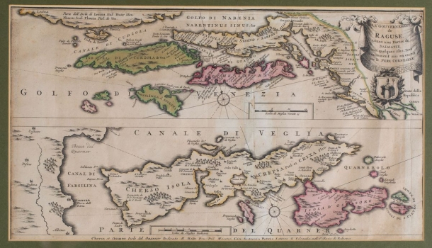
On the same sheet there are two maps, one of the Republic of Dubrovnik and below it a map of the Kvarner Bay with the islands of Cres (Cherso) and Lošinj (Isola d’Ossoro). The map of Dubrovnik's estates is a rather rare representation of that part of the southern eastern Adriatic coast, especially from the workshop of Venetian cartographers. Even the border of the land estates of the Republic of Dubrovnik towards the Ottoman hinterland (Confini dello Stato) was drawn, as well as the coat of arms of the patron saint of St. Vlaho (St. Blasius). The maritime borders between the Dubrovnik and Venetian estates were not drawn. The wider area of the Venetian estates from Hvar and Korčula with Lastovo and Mljet (I. de Meleda) to Venetian Albania on the mainland coast is shown. At the same time, a map is described which is very similar to Coronelli's map of Dubrovnik from the Atlanta Veneto atlas entitled Stato di Ragusi: Bocca del Fiume Narenta, Isole di Lesina e Curzola nella Dalmatia prosedutte Dalla Serenissima Republica di Venetia / P. [Vincenzo Maria] Coronelli., with the inventory number 163. In the lower part of the sheet on the second map there are the Kvarner islands (Cres and Lošinj) with the southeastern part of the Istrian coast, with a description and dedication to the famous inhabitant of Cres located below the lower edge (Cherso et Ossoro Isole del Quarner Dedicate Al Molto Reu Pre Maestro Gio Antonio Petris Lettore di Filosofia in the College of Bologna). A compass rose is centrally located on both maps as a tool for more precise orientation. Below each of the maps is a separate graphic scale. This cartographic product of the Venetian cartographer Coronelli was published in the Amsterdam workshop of Peter Schenk Jr. (Nunc apud Petrum Schenk Jun.).
SCHENK, PETER
