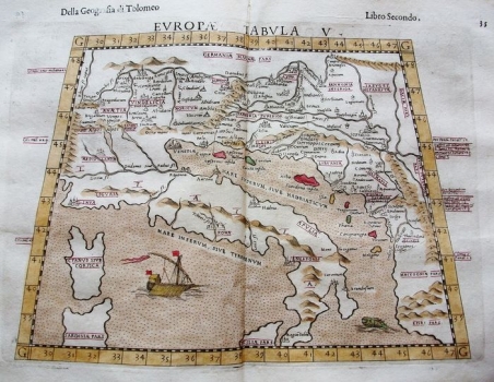
FIFTH MAP OF EUROPE
This Fifth Map of Europe is a late adaptation of the classic Ptolemy plate depicting Roman provinces on the eastern Adriatic coast, all the way to the border on the Drava and Danube Rivers in the north and west. Regarding the Croatian countries, the author recorded the horonyms Pannonia Superior, Illiris, Libvrnia and Dalmatia. The colours of the eastern Adriatic islands and the richly decorated boat in the Tyrrhenian Sea are especially pronounced. With the large amount of arbitrariness in the representation of the relief and hydrography, which was common for Ptolemy's versions, there is a noticeable lack of knowledge of the contours of the Adriatic coastal areas. The same publishing house, Sessa, which for a half of a century intensively collaborated with Ruscelli as the greatest Italian expert in adaptations of the maps from Ptolemy's Geography at the very end of the 16th century, published this Rosaccio version of the map in the work La Geografia di Claudio Tolomeo Alessandrino, Tradotta di Greco nell'Idioma Volgare Italiano, da Girolamo Ruscelli, et hora nuovamente ampliata da Gioseffo Rosaccio ...... Of course, this work is also based on the maps by Ruscelli and his role models. The publisher was probably also one of the heirs in the Sessa family. The great similarity of this map is noticeable precisely with the map of the same name by G. Ruscelli from the Felbar Collection (inv. no. 70), although it is smaller in size and it was published during his lifetime in the 1560s. There is a striking similarity to the exceptionally richly decorated Münster map of the same name (inv. no. 120). Although of similar dimensions, this is still a completely different plate, with the detail of the rich text cartouche in the lower left corner. A slightly smaller similarity of this map is also noticeable in comparison with some of the other versions of the Five Maps of Europe from Geography, which are also in the Felbar Collection. They are of different dimensions and decorations, inconsistent dates, and shifted views or ranges of territories displayed on the map. For comparison, the Stirk map (inv. no. 33) or the Waldseemüller map (inv. no. 97, 105 and 269) may be used. Within this map, numerical values of geographical coordinates are entered, which is one of Ptolemy's greatest merits for the development of cartography.

