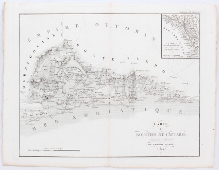
MAP OF THE BAY OF KOTOR
Inventory number 553
Original title: Carte des Bouches de Cattaro
Publishing year: 1824
Place of publishing and publisher: Paris
Format: 46,5 x 37 cm
Technique: Copper engraving
What is interesting about this detailed map of the Bay of Kotor is the former Ottoman corridor near Sutorina, clearly separated by a border line. Famous French cartographer and engraver Ambroise Tardieu, from a big family prominent in the cartographic world, performed geographical duties in the service of the French government and also acted as a publisher. He particularly emphasized the traffic communications on this map. The title cartouche is located in the bottom corner of the map and the graphic scale is in the left corner. A map is inserted in the upper left corner, clearly placing the main map of Kotor in the spatial context of the southern part of the eastern Adriatic coast, with the Ottoman Empire in the hinterland (Empire Ottoman), and the neighbouring northern (Etat de Raguse, Herzegowine) and southern (Montenegro, Albania) countries which surround it. Above the upper edge of the map are symbols marking the conquests in 1806 and 1807.
TARDIEU, AMBROISE
AMBROISE TARDIEU (1788-1841 or 1846), an esteemed French cartographer and printmaker, especially known for his own issue of John Arrowsmith’s map of the United States of America from 1806. He worked as a copper engraver at the Dépot de la Marine. The Tardieu family, and especially his uncle Pierre, were known for their graphic skills, while Ambroise's son Augusta Ambroise Tardieu studied forensic medicine and also worked in graphics. In addition to the maps of America and the Pacific Ocean, his portraits (more than 800 copies) are known, as well as plans and maps of for example Paris or Cordoba. Ambroise Tardieu Sr. published several atlases, including the Atlas universel de geographie, ancienne et moderne/dresse par Ambroise Tardieu pour l'intelligence de la Geographie universelle par Malte-Brun. He also collaborated with the military cartographers of Napoleon Bonaparte, for whom he also produced a map of Kotor, published in the multi-volume edition of Mathieu Dumas’ Précis des Évènements militaires ou Essai historique sur les Campagnes de 1799 à 1814., avec Plans et Cartes par M. le Comte Mathieu Dumas, Lieutenant - Général des Armées du Roi.