PAZZINI CARLI, VINCENZO: MAP OF EASTERN PART OF VENETIAN TERRITORIES
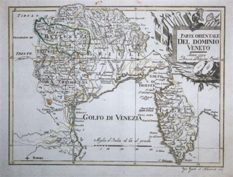
The map depicts Venetian territories in northern Italy, but north of the town on the lagoons, namely Furlania (Friuli) and Istria, as part of the Serenissima overseas territories. The river Po and the city of Ferrara constitute the southern border of the represented lands. The title cartouche in the upper right corner of the map gives the attribution and the data: Siena 1794, Presso Pazzini Carli. It defines the depicted countries as Eastern Venetian territories. Maps for the Pazzini publishing house were produced by Bartolomeo Borghi, so he probably collaborated on this map, too. The cartouche is richly decorated with images of war equipment such as flags, cold weapons and war drums. The boundary lines on this copper plate are dyed in two colours. The boundary of the region is particularly emphasized with green to the Tyrol (Bellunese), while the wider city area of Venice, as the central part of the Republic – the Duchy of Venice (Dogado), and parts of the landfill (Terraferma), such as Marca Trevigiana in the deeper hinterland, Felirino towards Trento or Friuli province. Horonym Padovano was entered on the map, but for this area the author had very poor data. The territories in Dalmatia and Venetian Albania are also omitted. Geographic coordinates are indicated along the map frame, and the graphical scale expressed in Italian miles is at the bottom edge. The map includes the presentation of entire Istria, although the Venetian estate in the west is clearly separated with a boundary. The author showed more cartographic details for the Venetian part of Istria than for the western part of the peninsula, or the Pazin Principality under the Austrian administration. The map is specific for representing the road traffic communication between Trieste and Venice, via Goriška and Treviso.
PAZZINI, CARLO
