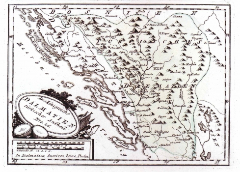
REILLY, FRANZ JOHANN JOSEPH VON: MAP OF THE TURKISH REGION IN DALMATIA
The map shows Dalmatia from Žrnovnica to Dubrovnik with its inland area. The delineation of boundaries is indicated between the Venetian region in Dalmatia and Ottoman possessions in Bosnia. The green colored area of "Türkisch Dalmatien", delineates the region which is today Herzegovina, at that time under Turkish administration. The Republic of Venice considered it as its zone of interest that's why was named "Turkish Dalmatia". The topography is shown arbitrarily with shaded molehills - a technique already for long forsaken. The title is shown in a simple oval cartouche surrounded by military symbols - trumpets, drums and banners. A mileage scale is in Italian, Turkish and German miles. This map is from Reilly's atlas "Schauplatz der Welt Atlas" 1789-1791.
REILLY, FRANZ JOHANN JOSEPH VON
