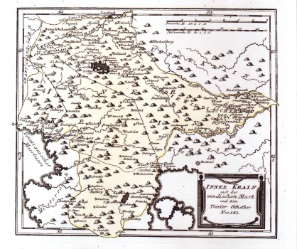
MAP OF THE INNER CARNIOLA WITH WINDISCH MARK
Inner Krain mit der Windischen Mark und dem Triester Gebiethe: Nro 143/ Frnz Johan Joseph von Reilly
Wien: Ignaz Albrecht: 1789
Copper engraving; 61 x 23,2 cm
No. 71
This map shows the inner Carniola's area comprised between the rivers Krka and Kupa. The map includes also the county of Pazin in Istria. Shaded molehills that represent the relief are evenly spread all over the area, leaving the vague impression about its configuration. Forested areas are represented by a tree-symbol. Also, the position of the lake of Cernik is stressed. In the Istria is to be seen the lake of Čepić. Both lakes are represented greater than in reality. The border between Istria and Carniola is indicated by dotted line. The post routes Ljubljana-Postoja-Rijeka and Rijeka-Trst are indicated with continuous line. The title of the map is in the lower right corner of the map in a simple panel. A mileage scale is in German (Deutsche M.) and in Italian miles (Italienische M.). This map was published in Reilly's atlas "Schauplatz der Welt Atlas" 1789-1791.
REILLY, FRANZ JOHANN JOSEPH VON
