SALMON, GIOVANNI: MAP OF ISTRIA
Inventory number 184
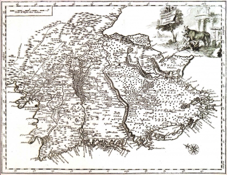
Original title: Carta geografica dell’ Istria
Publishing year: 1753
Place of publishing and publisher: Venezia
Format: 35 x 44 cm
Technique: Coloured copper engraving
The map was published in Salmon's work "Lo stato presente di tutti I paesi e popoli del mondo". It shows Istria with the territories of Venetian Istria and the County of Pazin, under Hapsburg-Monarchy rule, distinctively marked. The map features a fine representation of Mirna and Dragonja rivers together with their tributary streams. The Lim channel is shown much larger than it actually is. The coast is shown in a more realistic way than the interior of the peninsula. The fact that the coast is presented with much more place names compared to those indicated inland, suggests that the author used the Venetian nautical charts as his sources. The title of the map is in the upper right corner, next to the illustration featuring pastoral scenes and fragments of classical antiquity architecture. A mileage scale is expressed in Italian miles.
SALMON, GIOVANNI
SALMON, GIOVANNI (IVAN, THOMAS) (1679-1767), an English historian and geographer who worked in Venice. He published maps of Istria and Dalmatia in the book Lo stato presente di tutti i paesi e popoli del Mondo, which was published by Albrizzi in Venice in 1734 and 1753, and by Ricciardo in Naples in 1738, 1744 and 1746. Among his published works are some maps of Istria and Dalmatia. In the mid 1730s he accompanied George Anso on his travels across the world. In the creation of his maps, he apparently used Venetian nautical maps of the areas in question. He published Modern History in 1725-1738, whereby he collaborated with Moll on the creation of the maps. In the mid-century, he published The Universal Traveler, or a Complete Description of the several Nations of the World in London.