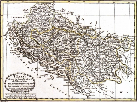
PAZZINI CARLI, VINCENZO: MAP OF THE REGION EXTENDING BETWEEN THE RIVERS DRAVA AND DANUBE AND THE ADRIATIC SEA
This map comes from the atlas published in Siena, in 1788, at Carlo Pazzini's printing house. It shows the region of Slavonia, Croatia, Dalmatia, Bosnia and Serbia or as stated in its title the region bounded on the north by the rivers Drava and Danube and on the south by the Adriatic Sea. According to the explanations contained in the map's legend the area coloured yellow shows the territory forming part of the Ottoman Empire, the pink area comprises regions being part of the Republic of Venice, while the territory of the Republic of Dubrovnik and the regions ruled by the Hapsburg Monarchy are coloured green. The title of the map is in the lower left corner. A mileage scale is expressed in Italian and Turkish miles. The engraver's signature saying: Ago. Costa sct.. is placed on the left-corner bottom margin.
PAZZINI, CARLO
