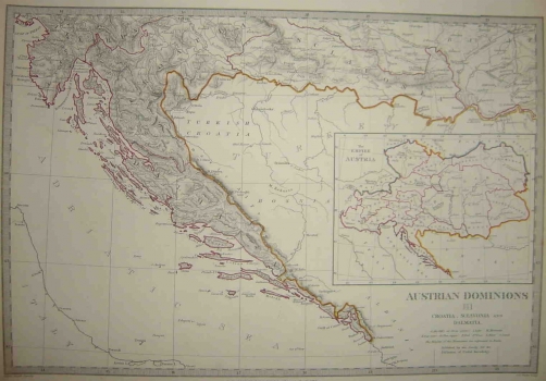
SOCIETY FOR THE DIFFUSION OF USEFUL KNOWLEDGE (S.D.U.K.): MAP OF THE AUSTRIAN LANDS CROATIA, SLAVONIA AND DALMATIA
Inventory number 311
Author: SDUK
Original title: Austrian Dominions III: Croatia, Sclavonia and Dalmatia
Publishing year: 1844
Place of publishing and publisher: London
Format: 36,5 x 39 cm
Technique: Partially coloured lithograph
This map shows the lands making up the state association of the Habsburg Monarchy that also included all of the Croatian lands: Croatia, Slavonia along with the Military border, Istria and Dalmatia. Along the right map’s margin there is an inset map entitled «The Empire of Austria», on which the entire territory of the Monarchy is showed with the boundaries between single countries delineated. This map comes from the atlas issued by the British association Society for the diffusion of useful knowledge (S.D.U.K). The first volume of this atlas was published in London in 1832, and the second out of which comes this map was published in 1844.
SDUK
Society for the Diffusion of Useful Knowledge (S.D.U.K), an English society that published and co-financed the printing of maps of the European countries during the first half of the 19th century (1826-1848). These included maps of the Habsburg estates, including Croatia, Slavonia, the Habsburg Military Frontier, Istria and Dalmatia, as these countries were of interest to British users. As their publishers, the society used the office Chapman and Hall. The society was established in 1826 by lord Brougham in London, with the intention of publishing publications for self-education. As the number of users grew exponentially, subsidiaries of the society were established in the USA.
