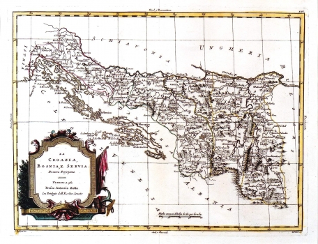
PITTERI, GIOVANNI MARCO: MAP OF CROATIA, BOSNIA AND SERBIA
Inventory number 75
Author: PITTERI, GIOVANNI
Original title: La Croazia, Bosniae e Servia, Di nuova Projezione
Publishing year: 1781
Place of publishing and publisher: Venezia, Antonio Zatta
Format: 32,5 x 42 cm
Technique: Coloured copper engraving
This map comes from Zatta's atlas "Atlante Nuovissimo". It is an administrative map, on which the south part of Croatia lying south of Sava, Bosnia and Serbia are represented. The delineation of administrative unit boundaries (sanžaks) is also indicated. The whole cartographic image shows serious deformation, and elements of relief are represented as shaded molehills. The title is shown in the lower left corner in a classicist cartouche. The signatures of engravers are placed below the bottom margin of the map: G. Zuliani inc", and on the right "G. Pitteri scr". A mileage scale is in common Italian miles (Miglia communi d'Italia).
PITTERI, GIOVANNI
PITTERI, GIOVANNI MARCO (1703-1767), an Italian engraver of the late Baroque period. He lived and worked in Venice. He was most known for his very detailed portraits that were almost photographic in their precision. As a cartographic engraver, he worked with Pasquali and Zuliani on Zatta’s atlas Atlante Novissimo, which was published in Venice between 1775 and 1785. He mapped the Croatian territories after the withdrawal of the Ottomans, but approached the representation of the region rather arbitrarily, especially when it comes to the presentation of the terrain and hydrography.
