SCHREIBER, JOHANN GEORG: MAP OF CROATIA, SLAVONIA AND MUCH OF BOSNIA
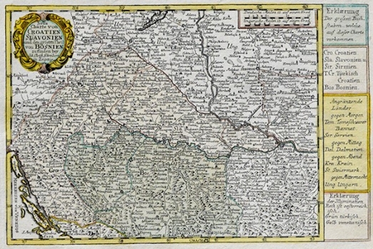
It seems likely that this map was included in Scrheiber’s most known work «Atlas Selectus»,which appeared in Leipzig in 1749. The author of the map is Johann Georg Schreiber and was engraved by his father Johann Christian. As stated in the map’s title it shows Croatia, Slavonia and much of Bosnia. The boundaries are outlined as fixed by the Treaty of Karlowitz signed in 1699 after which Slavonia was regained from the Ottoman Empire. The regions are individually coloured and distinguished between those under Austrian rule (pale rose), under Turkish rule (in green) and those under Venetian rule (pale yellow). It features a number of settlements, drainage network and the depiction of relief shown with shaded molehills. The title is in the upper left corner contained in a baroque cartouche. Along the right margin edge, besides the colour legend, there is the list of countries then bordering on Croatia, Slavonia and Bosnia. The map scale is in German and Hungarian miles.
SCHREIBER, JOHANN GEORG
