PERTHES, JUSTUS: MAP OF ADRIA
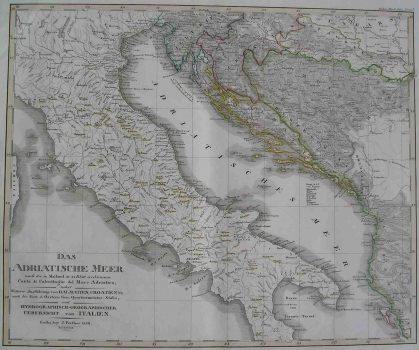
This map of the Adriatic Sea was published by one of the most eminent German cartographic publishers of the time, Justus Perthes from Gotha. The map was published in 1828 and this is its revised issue of 1846. It was included in Stielers’s Hand-Atlas with the work ordinal number 33. Besides the Adriatic Sea, the map shows all of the countries having the outlet to it including all of the Croatian lands (except for the western Podravina and Međimurje) with Bosnia. It was created through compilation of the map of the Adriatic made on 24 sheets based on the results from surveys of the coast and later surveys of Croatia and Dalmatia carried out by the Austrians and surveys of hydrographic and orographic features of Italy. The borders delimitating the Croatian lands comprise Slavonija and Croatia with the Military Frontier, Dalmatia and Istria, which in the period from 1809 to 1915 was incorporated as a part of the Austrian Illyrian province. The relief is shown by hachuring (short lines used on maps to shade or to indicate slopes and their degree and direction), which was the most often used method to represent relief. The title of the map is in its lower left corner.
PERTHES, JUSTUS
