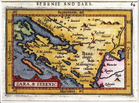
MAP OF ŠIBENIK AND ZADAR INLAND AREA
Inventory number 45
Author: ORTELIUS, ABRAHAM
Original title:
Publishing year:
Place of publishing and publisher:
Format:
Technique: Coloured copper engraving
Sebenie and Zara: Zara & Sebenic/ Abraham Ortelius
Antwerp: Philippo Gallaeo, 1588-1609
Colored copper engraving; 11 x 8 cm
No. 45
It is a reduced redrawing of the map of Zadar and Sibenik towns inland area made by Kolunić, edited by Bonifačić and issued in Ortelius' atlas. Ref. catalogue No. 59.
ORTELIUS, ABRAHAM
BRAHAM ORTELIUS (1527-1598), a 16th-century geographer and cartographer from Antwerp. He is the foremost Dutch cartographer of all times. After he studied engraving and cartography techniques, for a while he had made a living as a map illustrator. Yet, he made relatively small number of maps of his own. Today, only five maps are firmly recognized as personally drawn by him. The significance of Ortelius' work resides primarily in his efficiency at collecting of cartographic materials and in his atlas-making activities. Up to the year 1570 he gathered 70 maps, that he bound to form a book of the "Theatrum Orbis Terrarum", considered the world's first atlas in the modern sense. His atlas consisted of the maps produced by him or by other cartographers drawn upon various sources. On each map Ortelius identified the author of the map used as model, or the source the map was based upon. To the maps of the "Theatrum" the "Catalogus Auctorum" was appended, which is a list with the names of the cartographers known to him (87 names) and their works. Ortelius' atlas drew a great attention comparable only to the success that had Ptolemy's Geography. The "Theatrum Orbis Terrarum" went through 41 editions. How great Ortelius' reputation established by the success of his atlas was, can be seen from the fact that in 1575 he was designated royal geographer of Phillip II of Spain. Likewise Ptolemy's work, the "Theatrum" was enlarged in subsequent years trough the addition of new maps (the Additamenta").
