KARTE VON VENEDIG, DER PO-EBENE UND ISTRIEN
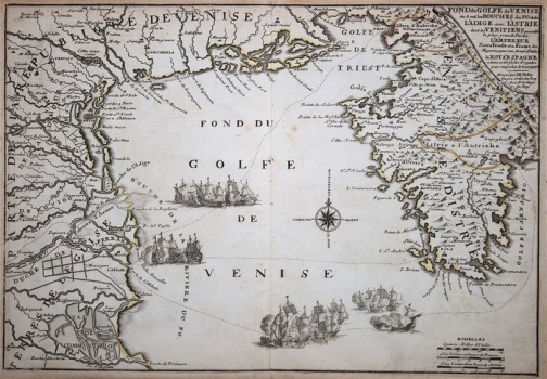
The map shows the Po River Valley (Bouche de la riviere du Po), the Venetian Lagoon with the possessions of the Republic, the Gulf of Trieste (Golfe de Triest) and the Istrian peninsula (Peninsule d'Istrie). It is a nearly identical variant of the same author's map from 1701-1702 (inv. no. 551 in the Felbar Collection), but this version was published in the work Theatre de la Guerre en Italie…. in 1705. The two maps are also distinguished by the text in the title cartouche in the upper right corner. Here too, the sailing ships on the Adriatic indicate war tensions due to the Ottoman presence in the eastern Adriatic at the beginning of the 18th century. The Venetian Terra ferma in the hinterland of the town in the lagoons is especially rich in information. The coloured border line between the Venetian and Austrian possessions (Pazin Shire – Istrie a l'Autriche) in the interior of Istria is interesting, although it was somewhat modified in comparison to Nolin’s map from 1702. The whole map seems to be a concise sketch or an attempt to create a more detailed and more accurate map. This is especially evident in the compression of data in the Po Valley. However, the prominent relief dynamics of Učka and Ćićarija are noticeable here as well. Also, despite the content compression, the depicted physical and social geographical inventory is much more balanced than on the old maps of the same area made by Camocio, Coppo, Bertelli or Forlani. In front of the western facade of Istria is a magnificent compass rose with cardinal and intercardinal directions. The sailing routes between Venice and Trieste, Pula and Rijeka are interesting.
NOLIN, JEAN BAPTISTE
