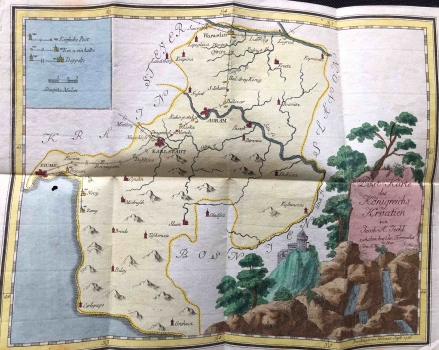
POSTAL MAP OF THE KINGDOM OF CROATIA
This thematic map of traffic communications with the postal stations shows the area of central and mountainous Croatia, from Varaždin in the north (Warasdin) to Rijeka (Fiume) in the west, Gračac in the south (Grahacz) and the Una River in the east. Specificity is also indicated in the small cartouche key in the upper left corner, which lists symbols for the marking of one-way and two-way stations along the route, as well as markings for those locations with partial one-way stations. Below the key is a graphical scale, measured in German miles. Postal stations are located on the route leading from Varaždin in the north, via Zagreb and Karlovac to Rijeka, with extensions to Bakar, Novi and Senj. Important forts such as Koprivnica, Križevci, Ivanić, Petrinja, Dubica, Gradiška, Slunj, Modruš, Belaj etc. are marked in red. In the bottom right corner is a nice decorative pastoral title cartouche.
MÜLLER, FRANZ THADE
