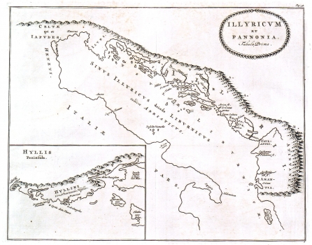
LUČIĆ, IVAN (IOANNES LUCIO): HISTORICAL MAP OF ILLYRICUM AND PANNONIA
This map is an unusual edition of Lučić’s map included in his work “De Regno Dalmatiae et Croatiae libri sex” published under the title “Illyricum et Liburnia: Tabula Prima”. The contents of both maps are identical. The only difference relates to the design of their titles and the pictorial modelling of the cartouches. It is interesting that Abraham Ortelius published a similar map a bit earlier entitled Pannoniae et Illyrici Veteris Tabula”, so it seems very likely that the publisher of this issue of Lučić's map, inspired by Ortelius, changed on his own initiative the title of Lučić's map from “ Illyricum et Liburnia” into “Illyricum et Pannonia” although this map shows no traces of Pannonia. The map shows Illyricum and Liburnia during their pre-Roman times. In the lower map’s part an inset map is added representing the area surrounding the town of Trogir with the islands of Brač, Čiovo and Drvenik. The place names scattered about the areas shown on the map relate to the rivers, islands and tribes that inhabited those areas (names of tribes are also given in the map by Ortelius!). Judging from the characteristic cartographic style of its cartouche, this map was produced sometime later than the map by Lučić edited by Bleau, presumably in some of the Dutch printing houses active around the end of the 17th century.
LUČIĆ, IVAN
